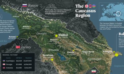
Dating all the way back to the 6th century BCE, the Imago Mundi is the oldest known world map, and it offers a unique glimpse into ancient perspectives on earth and the heavens. While this is the first-known interpretation of such a map, it would certainly not be the last. Today’s visualization, designed by Reddit user PisseGuri82, won the “Best of 2018 Map Contest” for depicting the evolving shapes of man-made maps throughout history.
AD 150: Once Upon A Time in Egypt
In this former location of the Roman Empire, Ptolemy was the first to use positions of latitude and longitude to map countries into his text Geographia. After these ancient maps were lost for centuries, Ptolemy’s work was rediscovered and reconstructed in the 15th century, serving as a foundation for cartography throughout the Middle Ages.
1050: Pointing to the Heavens
The creation of this quintessential medieval T-and-O Beatine map is attributed not to an unknown French monk, but to the Spanish monk Beatus of Liébana. Although it shows several continents—Africa, Asia, and Europe—its main objective was to visualize Biblical locations. For example, because the sun rises in the east, Paradise (The Garden of Eden) can be seen pointing upwards and towards Asia on the map.
1154: The World Turned Upside Down
The Arabic geographer Muhammad al-Idrisi made one of the most advanced medieval world maps for King Roger II of Sicily. The Tabula Rogeriana, which literally translates to “the book of pleasant journeys into faraway lands”, was ahead of the curve compared to contemporaries because it used information from traveler and merchant accounts. The original map was oriented south-up, which is why modern depictions show it upside down.
1375: The Zenith of Medieval Map Work
The Jewish cartographer Abraham Cresques created the most important map of the medieval period, the Catalan Atlas, with his son for Prince John of Aragon. It covers the “East and the West, and everything that, from the Strait [of Gibraltar] leads to the West”. Many Indian and Chinese cities can be identified, based on various voyages by the explorers Marco Polo and Sir John Mandeville. After this, the Age of Discovery truly began—and maps started to more closely resemble the world map as we know it today.
1489: Feeling Ptolemy and Polo’s Influences
The 15th century was a radical time for map-makers, once Ptolemy’s geographical drawings were re-discovered. Henricus Martellus expanded on Ptolemaic maps, and also relied on sources like Marco Polo’s travels to imagine the Old World. His milestone map closely resembles the oldest-surviving terrestrial globe, Erdapfel, created by cartographer Martin Behaim. Today, it’s preserved at the Yale University archives.
1529: A Well-Kept Spanish Secret
The first ever scientific world map is most widely attributed to the Portuguese cartographer Diego Ribero. The Padrón Real was the Spanish Crown’s official and secret master map, made from hundreds of sailors’ reports of any new lands and their coordinates.
1599: The Wright Idea
English mathematician and cartographer Edward Wright was the first to perfect the Mercator projection—which takes the Earth’s curvature into consideration. Otherwise known as a Wright-Molyneux world map, this linear representation of the earth’s cylindrical map quickly became the standard for navigation.
1778-1832: The Emergence of Modern World Maps
The invention of the marine chronometer transformed marine navigation—as ships were now able to detect both longitude and latitude. Jacques-Nicolas Bellin, a French geographer, was responsible for the 18th century’s highly accurate world maps and nautical charts. His designs favored functionality over the decorative flourishes of cartographers past. Finally, the German cartographer and lawyer Adolf Stieler was the man behind Stieler’s Handatlas, the leading German world atlas until the mid-20th century. His maps were famous for being updated based on new explorations, making them the most reliable map possible.
Is There Uncharted Territory Left?
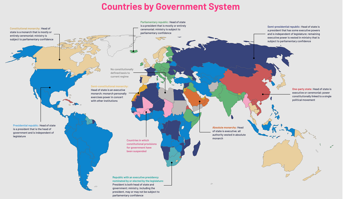
It is worth mentioning that these ancient maps above are mostly coming from a European perspective. That said, the Islamic Golden Age also boasts an impressive cartographic record, reaching its peak partially in thanks to Muhammad al-Idrisi in the 11th century. Similarly, Ancient Chinese empires had a cartographic golden age after the invention of the compass as well. Does this mean there’s nothing left to explore today? Quite the contrary. While we know so much about our landmasses, the undersea depths remain quite a mystery. In fact, we’ve explored more of outer space than we have 95% of our own oceans. If you liked the visualization above, be sure to explore the world’s borders by age, broken down impressively by the same designer. on Even while political regimes across these countries have changed over time, they’ve largely followed a few different types of governance. Today, every country can ultimately be classified into just nine broad forms of government systems. This map by Truman Du uses information from Wikipedia to map the government systems that rule the world today.
Countries By Type of Government
It’s important to note that this map charts government systems according to each country’s legal framework. Many countries have constitutions stating their de jure or legally recognized system of government, but their de facto or realized form of governance may be quite different. Here is a list of the stated government system of UN member states and observers as of January 2023: Let’s take a closer look at some of these systems.
Monarchies
Brought back into the spotlight after the death of Queen Elizabeth II of England in September 2022, this form of government has a single ruler. They carry titles from king and queen to sultan or emperor, and their government systems can be further divided into three modern types: constitutional, semi-constitutional, and absolute. A constitutional monarchy sees the monarch act as head of state within the parameters of a constitution, giving them little to no real power. For example, King Charles III is the head of 15 Commonwealth nations including Canada and Australia. However, each has their own head of government. On the other hand, a semi-constitutional monarchy lets the monarch or ruling royal family retain substantial political powers, as is the case in Jordan and Morocco. However, their monarchs still rule the country according to a democratic constitution and in concert with other institutions. Finally, an absolute monarchy is most like the monarchies of old, where the ruler has full power over governance, with modern examples including Saudi Arabia and Vatican City.
Republics
Unlike monarchies, the people hold the power in a republic government system, directly electing representatives to form government. Again, there are multiple types of modern republic governments: presidential, semi-presidential, and parliamentary. The presidential republic could be considered a direct progression from monarchies. This system has a strong and independent chief executive with extensive powers when it comes to domestic affairs and foreign policy. An example of this is the United States, where the President is both the head of state and the head of government. In a semi-presidential republic, the president is the head of state and has some executive powers that are independent of the legislature. However, the prime minister (or chancellor or equivalent title) is the head of government, responsible to the legislature along with the cabinet. Russia is a classic example of this type of government. The last type of republic system is parliamentary. In this system, the president is a figurehead, while the head of government holds real power and is validated by and accountable to the parliament. This type of system can be seen in Germany, Italy, and India and is akin to constitutional monarchies. It’s also important to point out that some parliamentary republic systems operate slightly differently. For example in South Africa, the president is both the head of state and government, but is elected directly by the legislature. This leaves them (and their ministries) potentially subject to parliamentary confidence.
One-Party State
Many of the systems above involve multiple political parties vying to rule and govern their respective countries. In a one-party state, also called a single-party state or single-party system, only one political party has the right to form government. All other political parties are either outlawed or only allowed limited participation in elections. In this system, a country’s head of state and head of government can be executive or ceremonial but political power is constitutionally linked to a single political movement. China is the most well-known example of this government system, with the General Secretary of the Communist Party of China ruling as the de facto leader since 1989.
Provisional
The final form of government is a provisional government formed as an interim or transitional government. In this system, an emergency governmental body is created to manage political transitions after the collapse of a government, or when a new state is formed. Often these evolve into fully constitutionalized systems, but sometimes they hold power for longer than expected. Some examples of countries that are considered provisional include Libya, Burkina Faso, and Chad.