The opening of the Erie Canal helped turn the city into a shipping powerhouse, and there was a building boom on the horizon. Cholera epidemics, fires, and riots swept through the city at various points. This fascinating interactive map, from Esri, is a snapshot of New York City during the tumultuous time (1836 to be exact), overlaid on the modern-day satellite map.
Getting the Lay of the Land
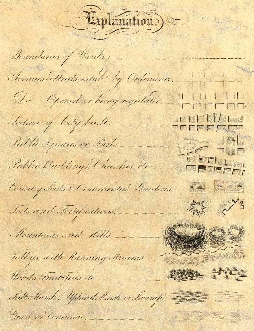
The base map used above is the stunning “Topographical Map Of The City and County Of New–York, and the adjacent Country”, published by the prodigious mapmaker, Joseph Colton. For easy viewing, the map’s legend is below:
This map includes all the usual features, such as roads and prominent buildings, but it also has some clever secondary information built in as well. For one, shading indicates ares that were more built-up at the time. There are also a number of visual techniques to indicate topographical features as well. After all, NYC wasn’t as extensive as it is today, and much of the land depicted in the map is still undeveloped. The full map is well worth exploring as well, as there are a number of beautiful illustrations throughout. Tool tip: Click the X on the info bar to hide it. (Mobile: Click the map, then the magnifying glass.)
The Big Picture: New York City in 1836
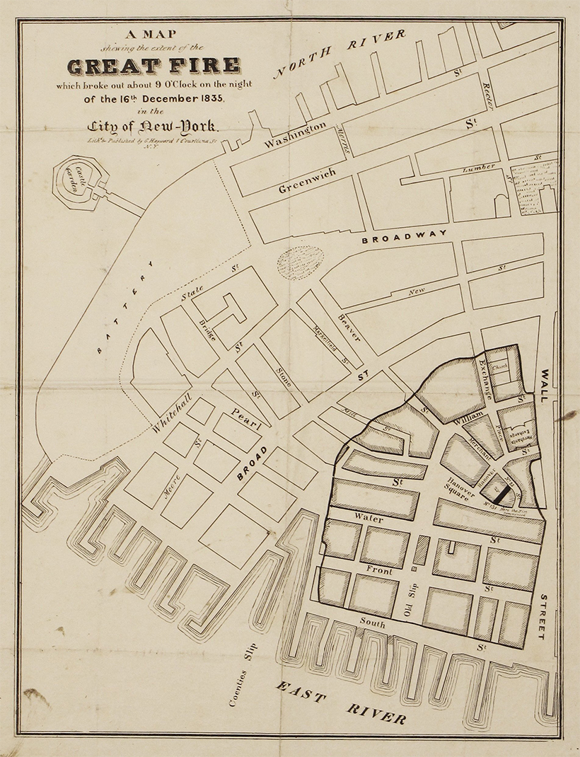
At this point in time, development in Lower Manhattan extended until about 14th Street, where buildings began to give way to open spaces. The city’s grid pattern was beginning to take shape, following the Commissioners’ Plan laid out in 1811. At the time, New York was anticipating massive growth, and the straightforward grid pattern was an efficient way to prepare the city for rapid expansion. In the 1800s, fire was an ever-present danger for city dwellers. In fact, a major fire tore through Lower Manhattan a year prior to when this map was published.
Points of Interest
There are a number of points worth visiting on this map.
Transit Begins to Take Shape
In the 1830s, New York City’s first railroad line—horse powered for its first few years—connected Prince Street to the Harlem River, accelerating the city’s expansion northward from Lower Manhattan. This route is still recognizable today as the Harlem Line.
Evolving Shorelines
One very obvious difference between the two maps is how much land has been reclaimed along shorelines in the area. Battery Park City, on the west side of downtown, and the Brooklyn Navy Yard are two prominent examples of infill. Randall’s Island, located near the top of Manhattan, is also an interesting place to observe changes in topography. Randall’s Island is actually made up of three islands that were eventually conjoined in the 1960s. This interactive map is a great place to explore changes to NYC’s shoreline over time.
Taming the Landscape
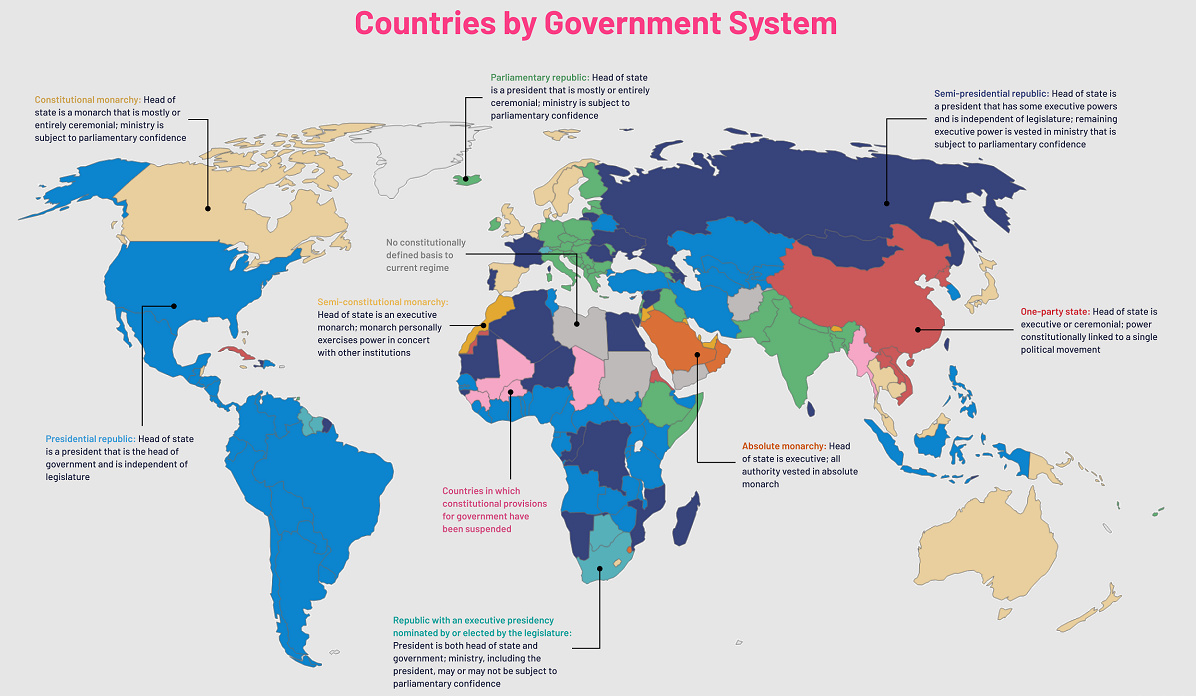
Midtown Manhattan is worth zooming into for a couple of reasons. First, the outline of Central Park is visible, although the park would officially be approved until almost 20 years later. As well, this topographical map clearly shows the numerous outcroppings spread across the island. Manhattan was far from flat in the 1800s, and it took a tremendous amount of effort—starting with gunpowder, pickaxes, and horse-drawn carts—to level the land. Looking at these historical maps is a reminder that the New York City we know today is the product of hundreds of years of human effort, and that cities continue to evolve over time. on Even while political regimes across these countries have changed over time, they’ve largely followed a few different types of governance. Today, every country can ultimately be classified into just nine broad forms of government systems. This map by Truman Du uses information from Wikipedia to map the government systems that rule the world today.
Countries By Type of Government
It’s important to note that this map charts government systems according to each country’s legal framework. Many countries have constitutions stating their de jure or legally recognized system of government, but their de facto or realized form of governance may be quite different. Here is a list of the stated government system of UN member states and observers as of January 2023: Let’s take a closer look at some of these systems.
Monarchies
Brought back into the spotlight after the death of Queen Elizabeth II of England in September 2022, this form of government has a single ruler. They carry titles from king and queen to sultan or emperor, and their government systems can be further divided into three modern types: constitutional, semi-constitutional, and absolute. A constitutional monarchy sees the monarch act as head of state within the parameters of a constitution, giving them little to no real power. For example, King Charles III is the head of 15 Commonwealth nations including Canada and Australia. However, each has their own head of government. On the other hand, a semi-constitutional monarchy lets the monarch or ruling royal family retain substantial political powers, as is the case in Jordan and Morocco. However, their monarchs still rule the country according to a democratic constitution and in concert with other institutions. Finally, an absolute monarchy is most like the monarchies of old, where the ruler has full power over governance, with modern examples including Saudi Arabia and Vatican City.
Republics
Unlike monarchies, the people hold the power in a republic government system, directly electing representatives to form government. Again, there are multiple types of modern republic governments: presidential, semi-presidential, and parliamentary. The presidential republic could be considered a direct progression from monarchies. This system has a strong and independent chief executive with extensive powers when it comes to domestic affairs and foreign policy. An example of this is the United States, where the President is both the head of state and the head of government. In a semi-presidential republic, the president is the head of state and has some executive powers that are independent of the legislature. However, the prime minister (or chancellor or equivalent title) is the head of government, responsible to the legislature along with the cabinet. Russia is a classic example of this type of government. The last type of republic system is parliamentary. In this system, the president is a figurehead, while the head of government holds real power and is validated by and accountable to the parliament. This type of system can be seen in Germany, Italy, and India and is akin to constitutional monarchies. It’s also important to point out that some parliamentary republic systems operate slightly differently. For example in South Africa, the president is both the head of state and government, but is elected directly by the legislature. This leaves them (and their ministries) potentially subject to parliamentary confidence.
One-Party State
Many of the systems above involve multiple political parties vying to rule and govern their respective countries. In a one-party state, also called a single-party state or single-party system, only one political party has the right to form government. All other political parties are either outlawed or only allowed limited participation in elections. In this system, a country’s head of state and head of government can be executive or ceremonial but political power is constitutionally linked to a single political movement. China is the most well-known example of this government system, with the General Secretary of the Communist Party of China ruling as the de facto leader since 1989.
Provisional
The final form of government is a provisional government formed as an interim or transitional government. In this system, an emergency governmental body is created to manage political transitions after the collapse of a government, or when a new state is formed. Often these evolve into fully constitutionalized systems, but sometimes they hold power for longer than expected. Some examples of countries that are considered provisional include Libya, Burkina Faso, and Chad.