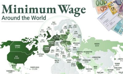
It’s likely you’re very familiar with the standard world map. It’s shown practically everywhere – you’ll see it online, on the news, in books, and even as a part of company logos. In fact, the world map is so ubiquitous that we don’t even really think about it much at all, really. The economist Max Roser from Our World in Data argues that this familiarity with the world map may lead to complacency in understanding global matters. After all, the typical world map shows us the basic geography of countries and continents, but it doesn’t give any indication of where people actually live!
Introducing: The Cartogram
To get around the challenges of relying on the standard world map, Roser instead has made a population cartogram based on 2018 population figures. What’s a population cartogram? A cartogram is a visualization in which statistical information is shown in diagrammatic form. In this case, it’s a population cartogram, where each square in the map represents 500,000 people in a country’s population. In total there are 15,266 squares, representing all 7.633 billion people on the planet. Countries like Canada or Russia – which have giant land masses but small relative populations – appear much smaller on this kind of map. Meanwhile, a country like Bangladesh grows much bigger, because it has a large population living within a smaller area.
The Regional View
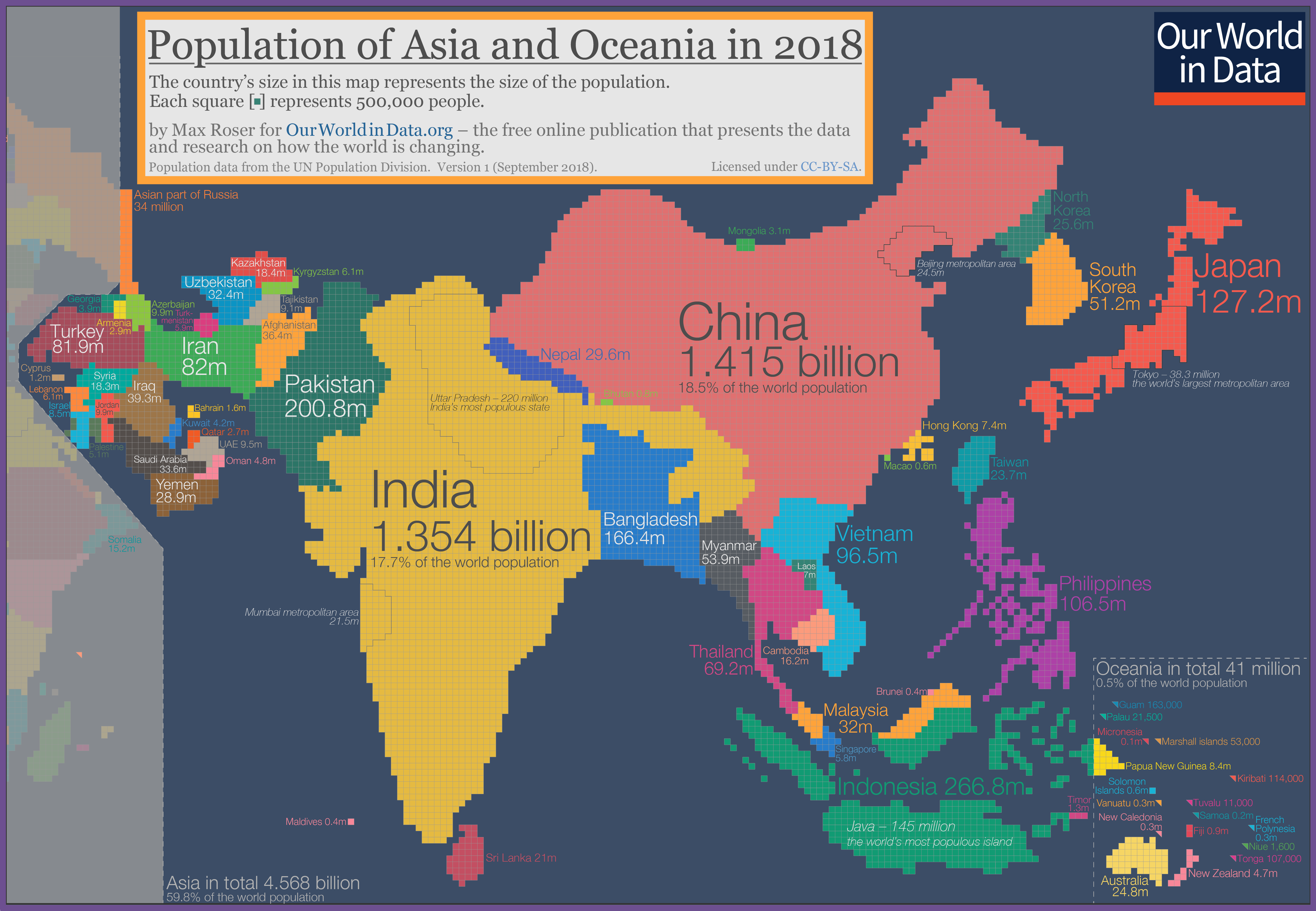
Let’s zoom in on some continental regions to get a sense of what we can learn from a population cartogram done in this fashion. Asia and Oceania Where did Australia go? The continent is completely dwarfed by neighboring Indonesia and the Philippines.
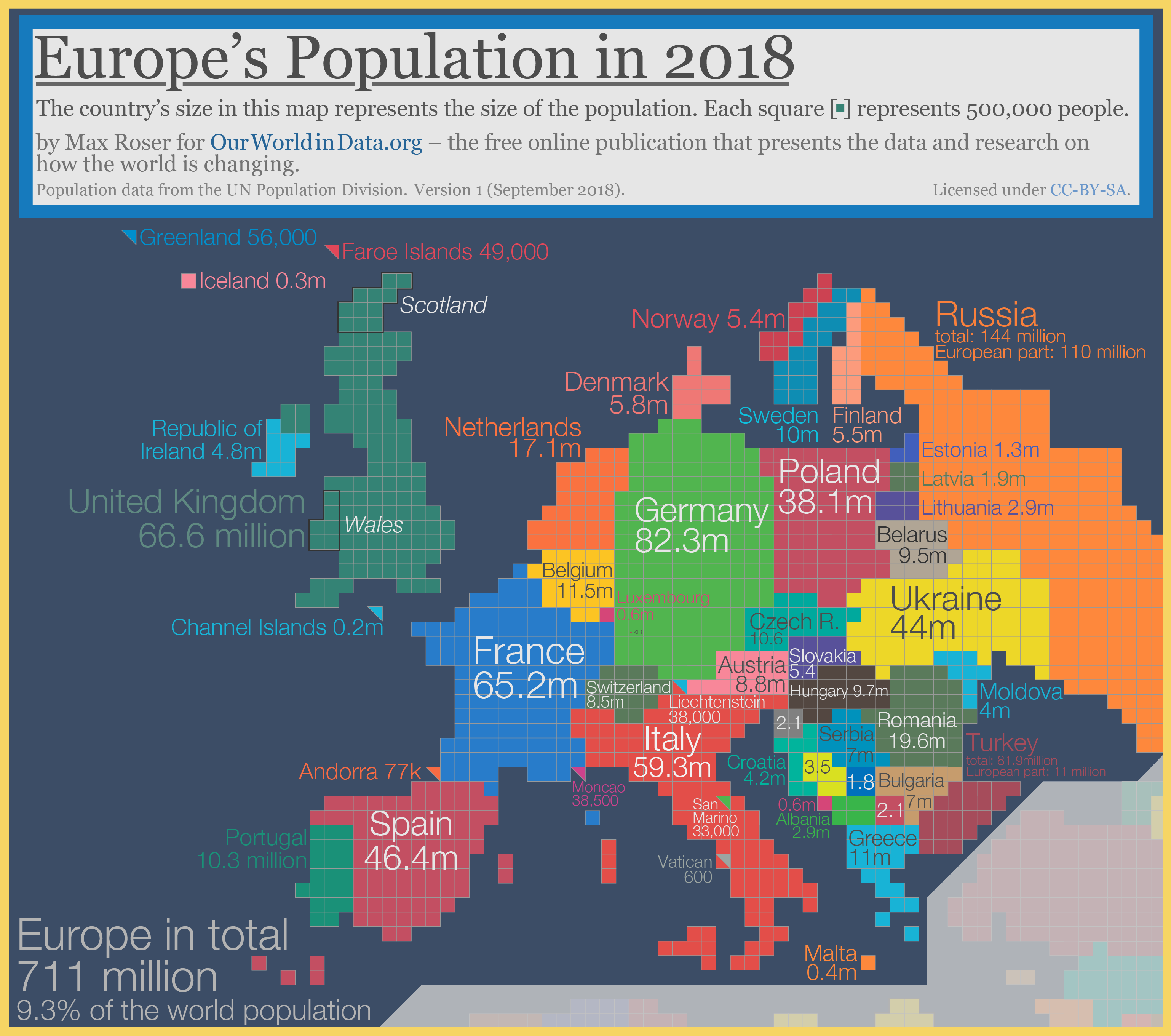
Not surprisingly, India and China are the biggest countries on this cartogram, especially looking oversized in comparison to countries in the Middle East like Saudi Arabia, Afghanistan, or the United Arab Emirates. Europe Geographically, Russia is a pretty massive country – but when resized based on population, the nation looks closer in size to many other European nations.
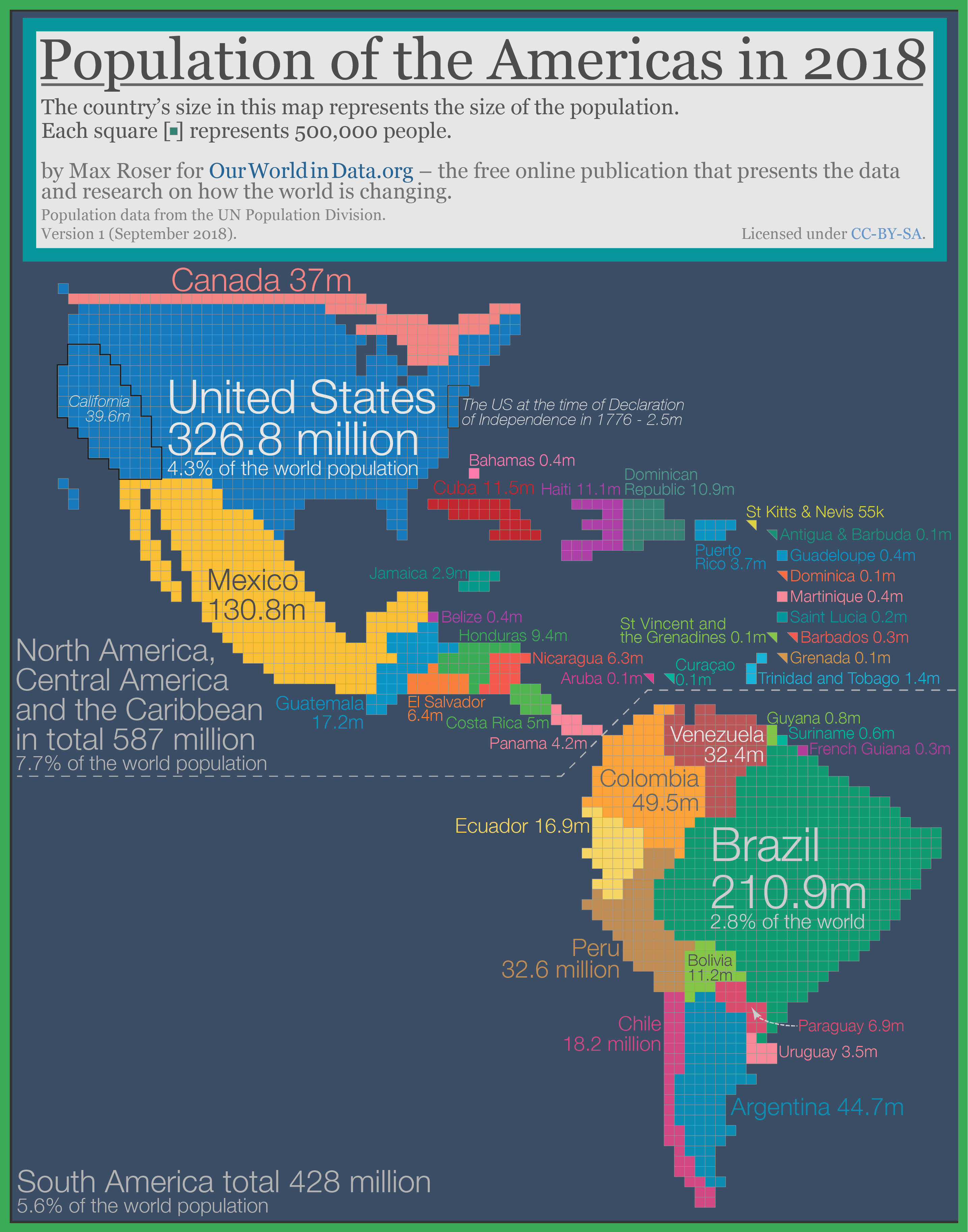
The Netherlands and Belgium, two countries with higher population densities than most European nations, also appear more prominent on this style of map. The Americas On the map below, Mexico has exploded to almost 4X the size of Canada. That’s because although the Great White North is the world’s second largest country in size, it only has a fraction of the population of Mexico.
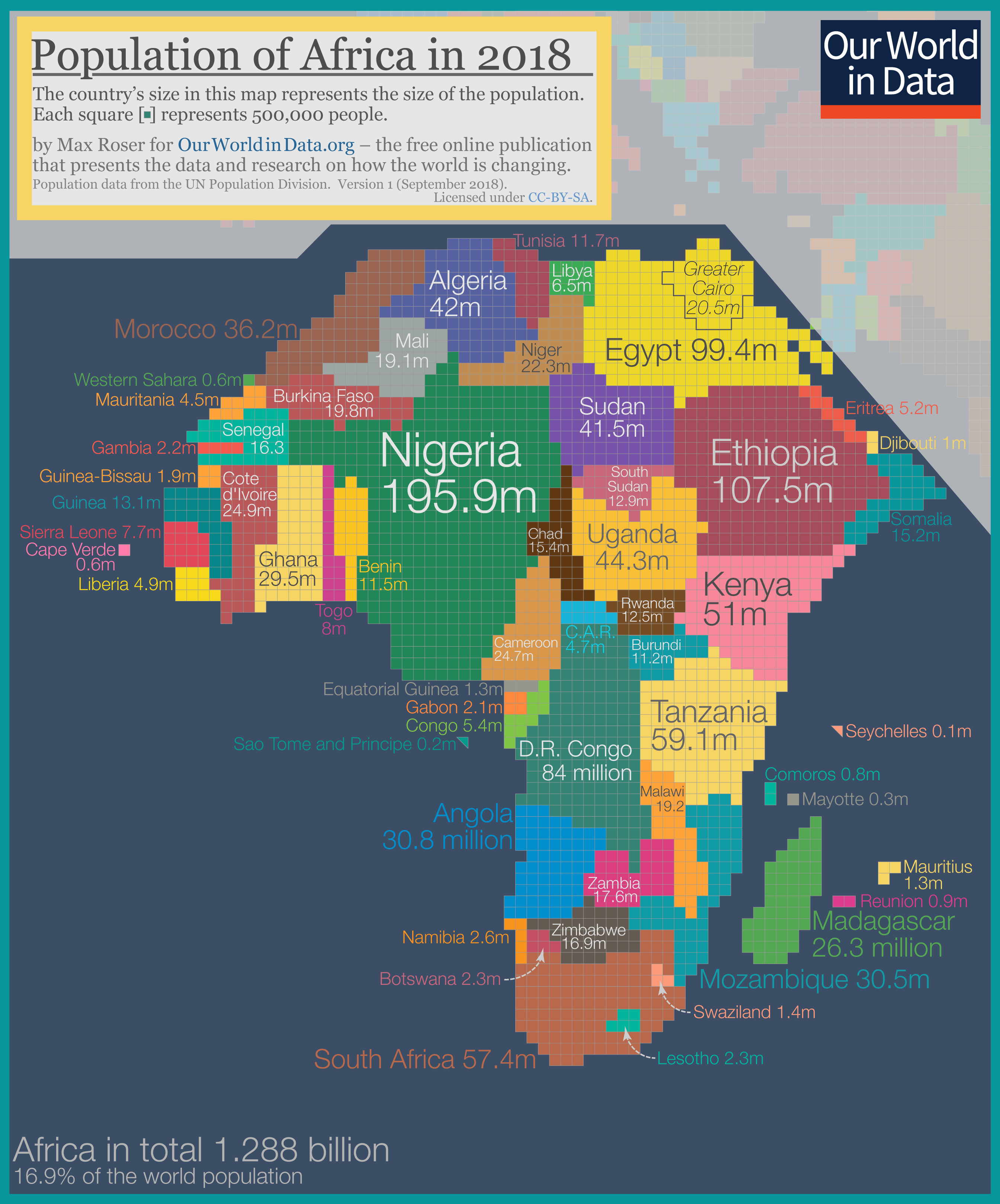
Meanwhile, it’s evident that Argentina’s population is lower than the country’s giant landmass leads on. Africa Finally, we’ll look at Africa, which is in the middle of a massive population boom.
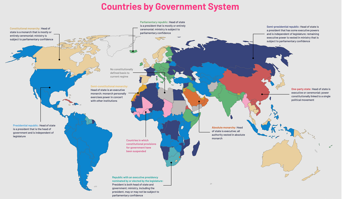
Countries like Namibia, Botswana, and Chad almost disappear. Nigeria, which is expected to have the world’s largest city by 2100 with over 88 million residents, is the largest country in Africa using this cartogram method. on Even while political regimes across these countries have changed over time, they’ve largely followed a few different types of governance. Today, every country can ultimately be classified into just nine broad forms of government systems. This map by Truman Du uses information from Wikipedia to map the government systems that rule the world today.
Countries By Type of Government
It’s important to note that this map charts government systems according to each country’s legal framework. Many countries have constitutions stating their de jure or legally recognized system of government, but their de facto or realized form of governance may be quite different. Here is a list of the stated government system of UN member states and observers as of January 2023: Let’s take a closer look at some of these systems.
Monarchies
Brought back into the spotlight after the death of Queen Elizabeth II of England in September 2022, this form of government has a single ruler. They carry titles from king and queen to sultan or emperor, and their government systems can be further divided into three modern types: constitutional, semi-constitutional, and absolute. A constitutional monarchy sees the monarch act as head of state within the parameters of a constitution, giving them little to no real power. For example, King Charles III is the head of 15 Commonwealth nations including Canada and Australia. However, each has their own head of government. On the other hand, a semi-constitutional monarchy lets the monarch or ruling royal family retain substantial political powers, as is the case in Jordan and Morocco. However, their monarchs still rule the country according to a democratic constitution and in concert with other institutions. Finally, an absolute monarchy is most like the monarchies of old, where the ruler has full power over governance, with modern examples including Saudi Arabia and Vatican City.
Republics
Unlike monarchies, the people hold the power in a republic government system, directly electing representatives to form government. Again, there are multiple types of modern republic governments: presidential, semi-presidential, and parliamentary. The presidential republic could be considered a direct progression from monarchies. This system has a strong and independent chief executive with extensive powers when it comes to domestic affairs and foreign policy. An example of this is the United States, where the President is both the head of state and the head of government. In a semi-presidential republic, the president is the head of state and has some executive powers that are independent of the legislature. However, the prime minister (or chancellor or equivalent title) is the head of government, responsible to the legislature along with the cabinet. Russia is a classic example of this type of government. The last type of republic system is parliamentary. In this system, the president is a figurehead, while the head of government holds real power and is validated by and accountable to the parliament. This type of system can be seen in Germany, Italy, and India and is akin to constitutional monarchies. It’s also important to point out that some parliamentary republic systems operate slightly differently. For example in South Africa, the president is both the head of state and government, but is elected directly by the legislature. This leaves them (and their ministries) potentially subject to parliamentary confidence.
One-Party State
Many of the systems above involve multiple political parties vying to rule and govern their respective countries. In a one-party state, also called a single-party state or single-party system, only one political party has the right to form government. All other political parties are either outlawed or only allowed limited participation in elections. In this system, a country’s head of state and head of government can be executive or ceremonial but political power is constitutionally linked to a single political movement. China is the most well-known example of this government system, with the General Secretary of the Communist Party of China ruling as the de facto leader since 1989.
Provisional
The final form of government is a provisional government formed as an interim or transitional government. In this system, an emergency governmental body is created to manage political transitions after the collapse of a government, or when a new state is formed. Often these evolve into fully constitutionalized systems, but sometimes they hold power for longer than expected. Some examples of countries that are considered provisional include Libya, Burkina Faso, and Chad.