Defined borders are a relatively new concept in many parts of the world. In fact, until the latter half of the 20th century, most of the world was still wide open territory with loosely or completely undefined borders. On the European continent, however, jurisdiction over territory has been a fact of life for thousands of years. In some cases, they’ve left a paper trail. In other cases, there are more concrete remnants. For example, over 3,000 miles (5,000 km) of simple frontier fortifications – known as limes – marked the edges of the Roman Empire at its greatest extent in the 2nd century. Over time, as territorial jurisdiction changed hands through war, marriage, and other arrangements, the map has been redrawn countless times. The video below demonstrates just how dramatically many of Europe’s dividing lines have shifted (even as recently as the 1990s).
Even today, borders are far from set in stone. Belgium and the Netherlands recently swapped land in order to simplify an overly complex piece of their border along a river. Also, India and Bangladesh worked together to solve a notoriously complicated situation involving enclaves within enclaves.
The Difficulty in Date Stamping Dividing Lines
Creating a map that shows the age of all the world’s borders seems like an impossible feat, but Reddit user, PisseGuri82, was up to the challenge. PisseGuri82, acknowledging the extreme complexity of the undertaking, outlined some caveats to consider: – The map looks at the date a border was officially set to its current form (excluding minute changes). – The dates are derived from publicly available border treaties and documents. – Exact dates are difficult to pin down as ratification, surveying, and physical marking can take place over a number of years. These issues aside, the final product is a fascinating look at how we’ve divided the world up into nations. Here are some highlights from the map: Static Spain In contrast to the patchwork of territories left in the wake of the Holy Roman Empire, the southwest part of Europe has remained remarkably static. The border dividing Spain and Andorra, weaving its way through the rocky Pyrenees mountain range, has remained unchanged since 1278, when a feudal charter solidified Andorra’s geography. The Portugal–Spain border has been in place since 1297. War and Pieces Many of the oldest borders in the world were established by treaties following a war. One particularly noteworthy example is the border between Iraq and Turkey, which was established by the Treaty of Zuhab (1639) following the sack of Baghdad by the Ottoman Empire. The Legacy of the “Scramble for Africa” It’s remarkable to note that a full third of the world’s borders are less than 100 years old. This is especially apparent in Africa, where many existing borders still resemble those haphazardly set by colonial powers around the turn of the 20th century. The average border on the continent is only 111 years old. -Lord Salisbury, British PM in 1890 In 1964, independent African states chose to maintain colonial borders, primarily to prevent widespread conflict over territory. Though colonial divisions were maintained in theory, only about one third of Africa’s 51,000 miles (83,000 km) of land borders are demarcated – an issue that continues to cause headaches today. For example, South Sudan has numerous border conflicts with neighbors; a situation that is complicated by the presence of natural resources. A recent study pointed out that the likelihood of conflict in Africa is approximately 40% higher in areas where “partitioned ethnicities reside, as compared to homelands of ethnicities that have not been separated by national borders”. Ice Slices There are seven sovereign states with pie-slice-shaped territorial claims in Antarctica. It’s worth noting that the claims have been recognized only between the countries making claims. There is currently a treaty in place that preserves freedom of scientific investigation and bans military activity on the continent. Saudi Arabia’s Lines in the Sand Saudi Arabia’s oldest border section – shared with Kuwait – is a remnant of the Uqair Convention circa 1922, but most of its international borders were established in the latter part of the 20th century. The Yemen–Saudi border was only officially demarcated in the year 2000, and a 1,100 miles (1,800 km) border fence soon followed.
Where will lines Shift next?
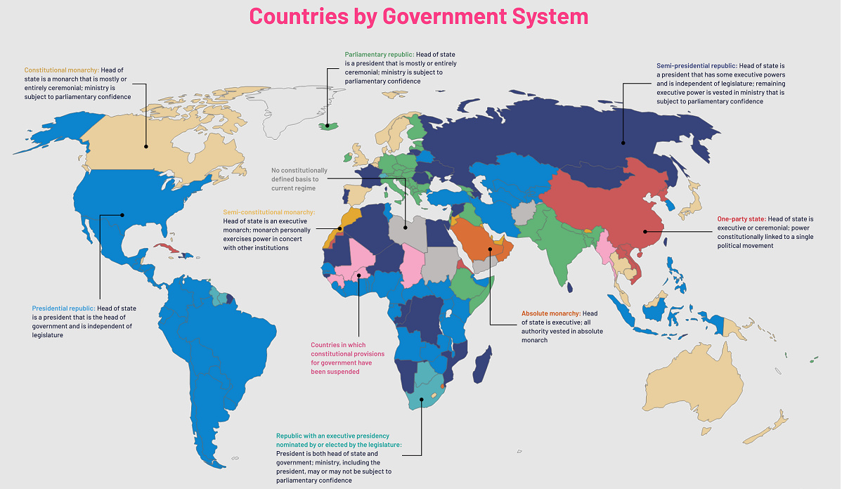
Where there is a war and upheaval, border changes often follow. Syria’s descent into chaos and the annexation of Crimea are two situations which could result in new international borders. Breakaway states – an independent Catalan state, for example – are always a possibility as well. For now, the most likely changes to borders will continue be minor adjustments to fix lawless gaps between nations. These corrections are rarely easy to negotiate, but irregularities, like the one that led to founding of Liberland, can cause even bigger headaches for governments and local officials. on Even while political regimes across these countries have changed over time, they’ve largely followed a few different types of governance. Today, every country can ultimately be classified into just nine broad forms of government systems. This map by Truman Du uses information from Wikipedia to map the government systems that rule the world today.
Countries By Type of Government
It’s important to note that this map charts government systems according to each country’s legal framework. Many countries have constitutions stating their de jure or legally recognized system of government, but their de facto or realized form of governance may be quite different. Here is a list of the stated government system of UN member states and observers as of January 2023: Let’s take a closer look at some of these systems.
Monarchies
Brought back into the spotlight after the death of Queen Elizabeth II of England in September 2022, this form of government has a single ruler. They carry titles from king and queen to sultan or emperor, and their government systems can be further divided into three modern types: constitutional, semi-constitutional, and absolute. A constitutional monarchy sees the monarch act as head of state within the parameters of a constitution, giving them little to no real power. For example, King Charles III is the head of 15 Commonwealth nations including Canada and Australia. However, each has their own head of government. On the other hand, a semi-constitutional monarchy lets the monarch or ruling royal family retain substantial political powers, as is the case in Jordan and Morocco. However, their monarchs still rule the country according to a democratic constitution and in concert with other institutions. Finally, an absolute monarchy is most like the monarchies of old, where the ruler has full power over governance, with modern examples including Saudi Arabia and Vatican City.
Republics
Unlike monarchies, the people hold the power in a republic government system, directly electing representatives to form government. Again, there are multiple types of modern republic governments: presidential, semi-presidential, and parliamentary. The presidential republic could be considered a direct progression from monarchies. This system has a strong and independent chief executive with extensive powers when it comes to domestic affairs and foreign policy. An example of this is the United States, where the President is both the head of state and the head of government. In a semi-presidential republic, the president is the head of state and has some executive powers that are independent of the legislature. However, the prime minister (or chancellor or equivalent title) is the head of government, responsible to the legislature along with the cabinet. Russia is a classic example of this type of government. The last type of republic system is parliamentary. In this system, the president is a figurehead, while the head of government holds real power and is validated by and accountable to the parliament. This type of system can be seen in Germany, Italy, and India and is akin to constitutional monarchies. It’s also important to point out that some parliamentary republic systems operate slightly differently. For example in South Africa, the president is both the head of state and government, but is elected directly by the legislature. This leaves them (and their ministries) potentially subject to parliamentary confidence.
One-Party State
Many of the systems above involve multiple political parties vying to rule and govern their respective countries. In a one-party state, also called a single-party state or single-party system, only one political party has the right to form government. All other political parties are either outlawed or only allowed limited participation in elections. In this system, a country’s head of state and head of government can be executive or ceremonial but political power is constitutionally linked to a single political movement. China is the most well-known example of this government system, with the General Secretary of the Communist Party of China ruling as the de facto leader since 1989.
Provisional
The final form of government is a provisional government formed as an interim or transitional government. In this system, an emergency governmental body is created to manage political transitions after the collapse of a government, or when a new state is formed. Often these evolve into fully constitutionalized systems, but sometimes they hold power for longer than expected. Some examples of countries that are considered provisional include Libya, Burkina Faso, and Chad.